Somerset Local Plan Scoping Consultation 2026
Spatial Strategy - where development could go
This section explains the different spatial strategy options being considered for the Somerset Local Plan.
A spatial strategy sets out the overall pattern, scale and distribution of development across Somerset. It helps show how the Plan’s vision will be delivered and how development and infrastructure can be coordinated.
At this stage, we are not selecting a preferred option. Instead, we have identified six main options, along with three additional options, for how development could be distributed. The numbering is not sequential because these options have been drawn from a longer list set out in the draft Spatial Strategy Topic Paper.
We are sharing these options to gather views from residents, businesses and stakeholders. Your feedback will help us refine the options and move towards a preferred spatial strategy for the Local Plan.
A draft Spatial Strategy Topic Paper is available which explains how these options were developed and the work carried out so far. This document will continue to be reviewed and updated as we receive feedback, new evidence becomes available, and national and local policy evolves. It will be finalised when the Local Plan is submitted for independent examination.
As you answer the questions, please refer to the supporting document and information provided. You may find it helpful to keep these open in separate tabs or windows.
Draft Spatial Strategy Topic Paper
You can download the draft Spatial Strategy Topic Paper to read, or view the document below.
Draft Spatial Strategy Topic Paper - Summary
The draft Spatial Strategy Topic Paper explains the main issues that help shape how development could be distributed across Somerset. These include:
- Role of settlements
- Past levels of development
- Capacity within existing urban areas
- Access to jobs and economic opportunities
- Infrastructure capacity
- Supporting rural communities
- New communities
- Climate change, flood risk and coastal change
- Protected landscapes
- Transport and connectivity
- Ecological sensitivity
- Opportunities for development
- Sites put forward through the Call for Sites
- Cross-boundary issues (working with neighbouring areas)
Health and wellbeing is not listed separately, but is considered a cross-cutting theme that is influenced by many of the factors above.
These issues were identified through a review of national and local policy, data analysis, early engagement, and work on the Local Plan evidence base. They were used to develop a range of possible spatial strategy options.
An initial list of 19 options was assessed against the emerging Local Plan objectives. From this, six main options and three additional options were selected for further consideration and public consultation.
The Topic Paper includes:
- An illustrative distribution of housing across the settlement hierarchy (Appendix 2)
- Indicative maps and diagrams showing how each option might look (Appendix 3)
These are for illustration only and help explain how development could be distributed. The options may change as work progresses.
The spatial strategy is closely linked to the Settlement Role and Function Study, which defines the proposed settlement hierarchy. There are separate questions about this in the consultation.
The options have also been subject to an initial Sustainability Appraisal (SA). There are separate questions on this as well.
We are now seeking your views on these options as part of the Local Plan Scoping Consultation. Your feedback, along with further technical work (including Sustainability Appraisal and Habitats Regulations Assessment), will help identify a preferred spatial strategy.
This preferred approach will then be used to help identify potential development sites, including those considered through the Housing and Economic Land Availability Assessment (HELAA).
The strategy may continue to be refined before a final version is included in the Draft Local Plan (Regulation 23) consultation, planned for 2027.
Core Spatial Strategy Maps (Appendix 3 of the draft Spatial Strategy Topic Paper)
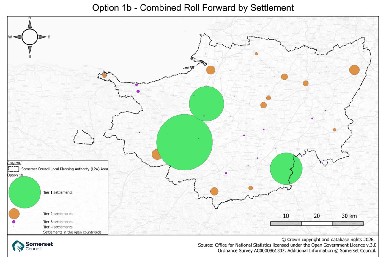
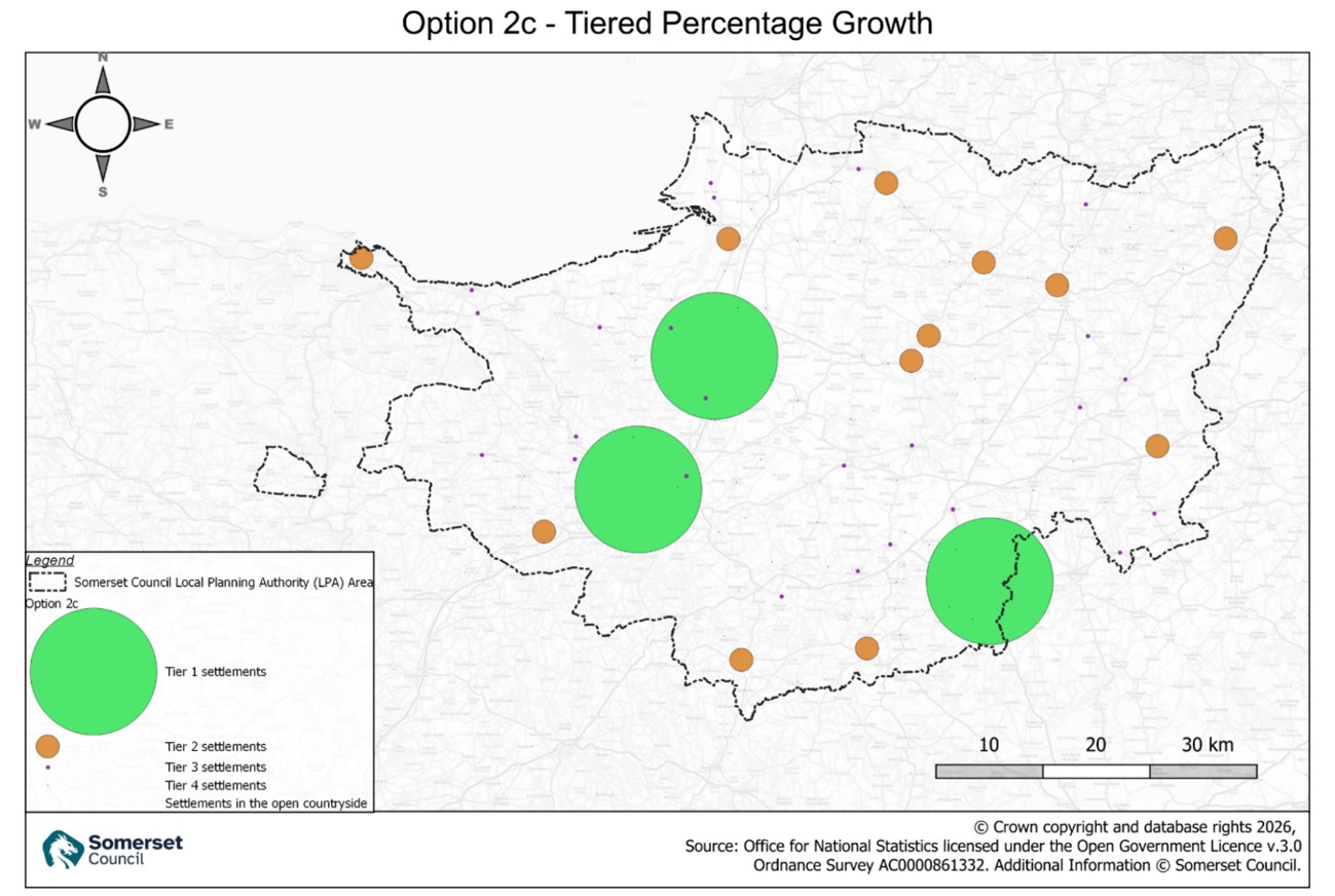
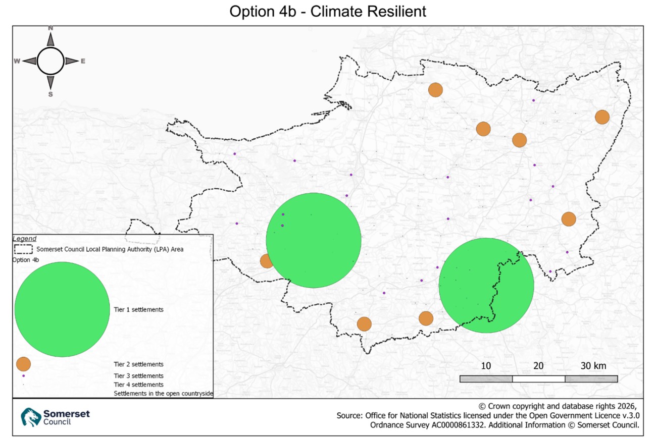
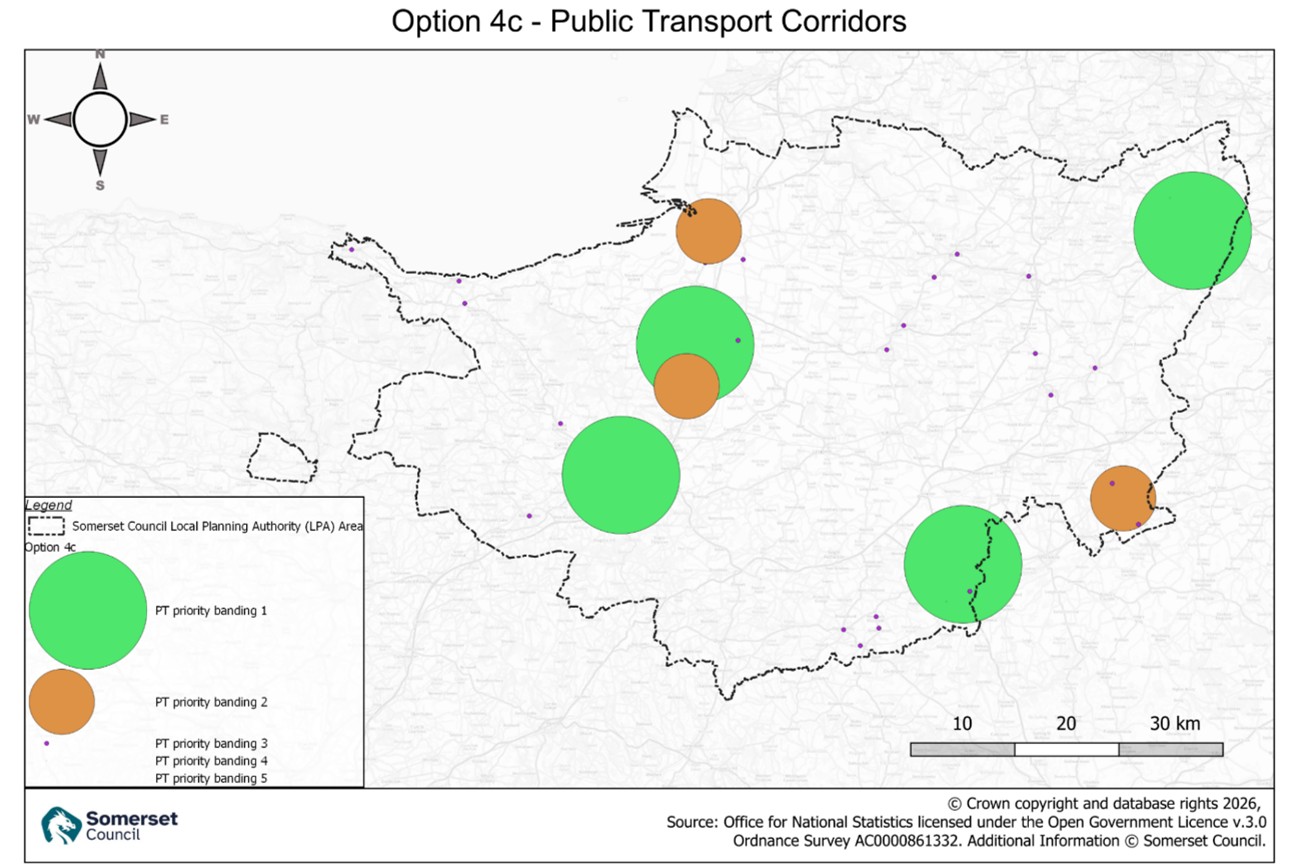
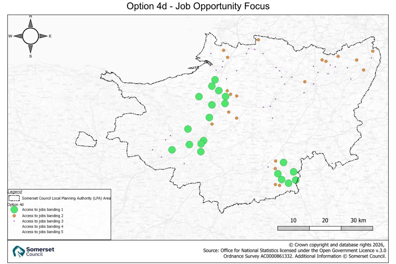
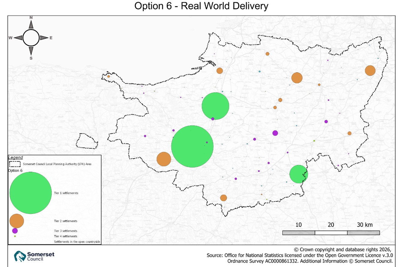
The maps below show illustrative versions of each of the six core spatial strategy options. Each map includes a dot for every settlement in the settlement hierarchy:
- The colour of the dot shows the settlement’s position in the hierarchy (or, for some options, a different grouping approach – explained in the main document)
- The size of the dot gives an indication of how much growth that settlement might accommodate under that option
These sizes are based on the potential housing figures set out in Appendix 1.
It is important to note that these maps are indicative only:
- They show the relative distribution of growth, not exact locations
- The dots do not represent development boundaries
- They do not mean all land within a dot is suitable for development
The maps are intended to help you compare the different options and understand how growth could be distributed across Somerset.
Core spatial strategy options |
|
| Option 1b | Combined Roll Forward by Settlement This seeks to reflect a roll forward of each area's existing plan spatial strategies, applied to the new plan period. |
| Option 2c | Tiered % Growth This seeks to reflect a proportional increase of dwellings in a settlement depending on its scale. |
| Option 4b | Climate Resilience This seeks to avoid significant growth in areas at greatest risk of impacts from climate change, including flood risk and coastal change. |
| Option 4c | Public Transport Corridors This seeks to maximise opportunities of locating growth in places with better access to public transport. |
| Option 4d | Job Opportunity Focus This seeks to maximise opportunities of locating growth close to higher density clusters of jobs. |
| Option 6 | Real World Delivery This seeks to reflect actual delivery patterns and market behaviour. It is a relatively rurally dispersed strategy. |
Potential spatial strategy options (not yet definable)
Potential spatial strategy options (not yet definable) |
|
| Option 5a/b | New Settlements Would involve consideration of the role of one or more new settlements, likely in combination with one of the above core options. Whether new settlements will be needed or not is not yet known. In addition to this, it should be recognised that due to the timescales involved in bringing new settlements forward, it is likely that they would generally only contribute limited delivery within the plan period. If it is considered necessary or preferable to consider new settlements longer-term, then the plan will likely need to establish selection criteria and areas of search at least. |
| Option 8 | Promoted sites Would involve consideration of sites promoted via the Call for Sites process and emerging as ‘potentially suitable’ or ‘potentially unsuitable’ within the initial HELAA report. |
| Option 9 | Blended strategy The preferred strategy will almost certainly be a blend of the above options, maximising the benefits and minimising the disbenefits of each. |