Somerset Local Plan Scoping Consultation 2026

Closes 24 Jul 2026

Sustainability Appraisal of Spatial Options - how the options impact on key issues

Sustainability Appraisal (SA) is a process which runs alongside and informs development of the Local Plan. It is not the decision-making process in itself, but highlights how different reasonable alternatives perform against an agreed Framework of SA Objectives. This highlights likely significant effects in relation to social, economic and environmental factors, and helps to understand implications of decisions on the plan, and what mitigations might be required. However, it only informs the decision making on the plan, and is not a substitute for it.

The SA Scoping Report published alongside the Local Plan Scoping Consultation includes the aforementioned SA Framework of Objectives, which have been informed by and iterated in response to consultation with the statutory consultation bodies (Environment Agency, Natural England and Historic England) and other early engagement work. However, the SA Scoping Report does not include any assessment of how the spatial strategy options perform against this Framework.

A separate Spatial Options Assessment Technical Note has been produced to undertake an initial high level assessment of how each of the spatial strategy options as listed above performs against the SA Framework. This Technical Note will be updated and revised in response to consultation feedback and document further work on iterating options and assessing their performance, and will in time be absorbed into the Draft SA Environmental Report anticipated to be published in support of the Draft Plan consultation on proposed content currently anticipated to be published in 2027.

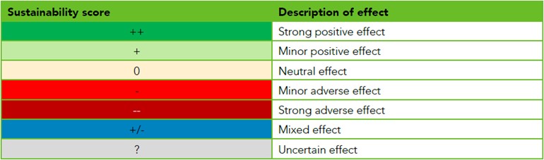
This high level assessment assigns a score against each SA Objective ranging from strong positive through to strong adverse, as indicated in the table below. These scores are indicative and provide a score relative to other options as opposed to being absolute scores which require more information on spatial distribution of individual sites. Future iterations will be based on absolute scores as this level of detail becomes available.

A table setting out Sustainability Appraisal (SA) scores and their meaning. It presents a range of scores from strong positive effects to strong adverse effects. Each score is accompanied by a short description explaining the expected level and direction of impact on the SA objective—for example, strong positive (major beneficial effect), minor positive (some beneficial effect), neutral (no overall effect), minor adverse (some negative effect), and strong adverse (major negative effect). The scores are indicative and used to compare options relative to each other rather than as absolute measures.

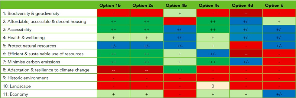
The assessments are based on a series of assumptions about potential impacts and the distribution of environmental constraints across Somerset. These assumptions are set out within Table 2.2 of the Technical Note.

The Spatial Options Assessment Technical Note includes the following table which summarises how each of the core options perform against the SA Framework. Further detail including narrative of how these scores are arrived at can be found within the Technical Note.

A colour-coded table comparing Sustainability Appraisal scores across six spatial options (Option 1b, Option 2c, Option 4b, Option 4c, Option 4d and Option 6) against eleven sustainability objectives listed down the left-hand side. The objectives are: biodiversity and geodiversity; affordable, accessible and decent housing; accessibility; health and wellbeing; protection of natural resources; efficient and sustainable use of resources; minimising carbon emissions; adaptation and resilience to climate change; historic environment; landscape; and economy. Each cell contains a score indicating the likely effect of that option on the objective, using symbols such as ‘++’ (strong positive), ‘+’ (positive), ‘+/-’ (mixed or uncertain), ‘0’ (neutral), ‘-’ (negative) and ‘--’ (strong adverse), supported by colour coding (greens for positive effects, blue for mixed effects, and reds for negative effects). Overall, Options 1b and 2c show strong positive effects for housing, accessibility, efficient resource use and carbon reduction, but negative effects for biodiversity, climate resilience, the historic environment and landscape. Option 4b shows a strong positive effect for climate resilience but more mixed or negative effects elsewhere, including housing and the historic environment. Option 4c performs positively for housing, accessibility and carbon reduction, with a neutral effect on landscape but negative effects for biodiversity and climate resilience. Option 4d shows a mix of uncertain effects across several objectives, with strong adverse effects for resource use and negative effects for biodiversity, natural resources, climate resilience and landscape. Option 6 shows generally mixed or negative effects overall, with some positive effects for housing, but negative scores for biodiversity, resource efficiency, carbon emissions, climate resilience, the historic environment and landscape. The table enables comparison of how each option performs across the full range of sustainability objectives.

As you answer the questions, please refer to the supporting document and information provided. You may find it helpful to keep these open in separate tabs or windows.

Spatial Options Assessment Technical Note

You can download the Spatial Options Assessment Technical Note to read, or view the document below:

Your browser does not support inline PDF viewing. Please download the PDF.


1. Do you agree with the assumptions underpinning assessment of Objective 1: Biodiversity and geodiversity?

Objective 1 - assumptions

Biodiversity interest in Somerset is widespread, but predominantly focussed outside of the existing settlements. Internationally and nationally designated sites are concentrated in the centre and north of the county, associated with the Somerset Levels and Severn Estuary.

Locally designated sites, including Local Nature Reserves, Local Wildlife Sites and Local Geological Sites, are widespread across the county, including the urban areas.

The HRA Screening and Scoping Report provides a high-level assessment of the potential for each of the six spatial strategy options to have adverse effects upon European sites in and around the county with respect to air quality, water quality, recreational disturbance and urbanisation effects. Therefore the assessment of impacts reported here relating to European sites has been drawn from that study. Key assumptions within that study include:

  • Water quality effects: Although each option involves growth within nutrient-sensitive catchments, those that direct higher levels of development outside nutrient neutrality areas (such as around Bridgwater and the northern parts of the Plan area) are expected to have fewer negative impacts;
  • Recreational disturbance effects: At a high-level impacts are likely to be reduced when development is focussed to the south of the Local Plan area where fewer European sites are located; and
  • Urbanisation effects: Focusing new development within or adjacent to existing built-up settlements can reduce the need to create new sources of urbanisation pressure. Spatial strategy options that direct a greater share of development to the south and southeast, where fewer European sites are located, are likely to pose a lower risk in terms of urbanisation impacts.
2. Do you agree with the assumptions underpinning assessment of Objective 2: Affordable & decent housing?

Objective 2 - assumptions

All options are considered to be able to deliver the full housing requirement for Somerset. In the Spatial Strategy Options Paper, Option 6 falls short of the full requirement, but only because the remainder would be delivered outside the listed settlements in the wider open countryside.

The most deprived communities in Somerset, falling within the 10% most deprived neighbourhoods in England (2025 census), are found in the Tier 1 settlements of Taunton, Yeovil and Bridgwater and the Tier 2 settlement of Highbridge.

In the majority of cases, larger sites provide opportunity for a greater range of types and sizes of home.

3. Do you agree with the assumptions underpinning assessment of Objective 3: Accessibility?

Objective 3 - assumptions

The prediction of accessibility effects has been informed by the Settlement Role and Function Study and scoring arising out of the WSP Accessibility Tool. The overall accessibility scores assigned in this study demonstrate increasing accessibility further up the settlement hierarchy, that is to say that the Tier 1 settlements have the highest accessibility, followed by the Tier 2 settlements etc. There is variability between settlements in each tier and in some instances, settlements do not follow the trend: for example North Petherton (Tier 3a) has a higher accessibility score than some Tier 2 settlements. But on the whole the settlements conform to this trend.

Development in general is likely to stimulate provision of new infrastructure, including new services and facilities which will benefit new and existing residents. This includes in rural communities, although the scale of development would need to be significant enough to improve provision of services.

4. Do you agree with the assumptions underpinning assessment of Objective 4: Health and wellbeing?

Objective 4 - assumptions

Settlements with higher levels of accessibility are more likely to provide residents with better access to health infrastructure including healthcare, food retail, sports facilities and open space which are all indicators of good health and wellbeing.

Higher levels of accessibility are more likely to provide opportunities for active travel with associated health benefits.

5. Do you agree with the assumptions underpinning assessment of Objective 5: Protect natural resources?

Objective 5 - assumptions

There is little Predictive Grade 1 and Grade 2 agricultural land in the county, although land around the fringes of some of the larger settlements does include pockets of Best and Most Versatile (BMV) agricultural resource, particularly Yeovil. Soilscapes data suggests that the most fertile soils are largely located in the north and east of the county.

Source protection zones extend within the settlements of Cheddar, Shepton Mallet, Frome, Crewkerne and South Petherton.

The only Air Quality Management Area (AQMA) in Somerset encompasses the entire built up area of Yeovil.

6. Do you agree with the assumptions underpinning assessment of Objective 6: Efficient and sustainable use of resources?

Objective 6 - assumptions

Higher density development is more likely to be appropriate in the larger settlements. Minerals safeguarding areas are spread throughout the county.

7. Do you agree with the assumptions underpinning assessment of Objective 7: Minimise carbon emissions?

Objective 7 - assumptions

Development in settlements with higher accessibility scores is considered to have lower associated carbon emissions as residents will be less reliant on private vehicles.

On the whole, digital connectivity and broadband speeds are higher in the urban areas, thereby providing better opportunities for working for home.

In terms of domestic carbon emissions, it is not possible to differentiate between spatial options based on their ability to connect directly into a renewables generation site; however, larger sites, which are more likely to come forward in the higher tier settlements, are likely to be better suited to having a direct connection and also have greater potential for district-heating networks.

Peaty soils are important carbon sinks. Developing on peaty soils can release large amounts of carbon into the atmosphere. There are areas of deep peaty soils and soils with peaty pockets throughout Somerset, with the deep peaty soils predominantly in the centre of the county; these are mostly located beyond the existing urban areas.

8. Do you agree with the assumptions underpinning assessment of Objective 8: Adaptation and resilience to climate change?

Objective 8 - assumptions

Development in the flood zone will be susceptible to the effects of flooding exacerbated by climate change.

Different soil types influence rates of runoff and infiltration and in turn the effectiveness of Sustainable urban Drainage Systems (SuDS). Soilscapes data indicate a range of soil types across the county. Impermeable soils could potentially exacerbate the effects of flooding and limit the effectiveness of SuDS.

Climate change adaptation and resilience will largely be site specific and dependent on how an individual development comes forward.

9. Do you agree with the assumptions underpinning assessment of Objective 9: Historic environment?

Objective 9 - assumptions

Heritage assets are spread throughout the county with listed buildings and conservation areas concentrated within settlements for the most part, including small villages. There are also a number of scheduled monuments, Registered Parks and Gardens (RPGs) and two battlefields in the county. Areas of archaeological importance are largely concentrated in the centre of the county outside the existing settlements for the most part. Heritage impacts, both direct and indirect through impacts to setting, will be highly location specific.

10. Do you agree with the assumptions underpinning assessment of Objective 10: Landscape?

Objective 10 - assumptions

There are a number of National Landscapes across Somerset and the Exmoor National Park lies in the west of the county. These areas will be highly sensitive to development, and development in proximity to these areas could adversely impact landscape character and alter views from within the sensitive areas. The Spatial Strategy Topic Paper acknowledges potential for impacts up to 2km from a designated landscape. Ultimately, the potential for a development to impact upon the landscape will depend upon its layout, design, orientation, scale, massing and material selection amongst other things.

11. Do you agree with the assumptions underpinning assessment of Objective 11: Economy?

Objective 11 - assumptions

Settlements with high levels of accessibility are more likely to provide residents with better access to employment and training opportunities.

Development within settlements is likely to contribute to the vitality and viability of these communities.

12. Core Spatial Strategy Options

Each core spatial strategy option has been subject to high level assessment. For a reminder on the options and how they score see below.

Core Spatial Strategy Options

1b – Combined Roll-Forward by Settlement - This seeks to reflect a roll forward of each area's existing plan spatial strategies, applied to the new plan period.

2c – Tiered % Growth - This seeks to reflect a proportional increase of dwellings in a settlement depending on its scale.

4b – Climate Resilience - This seeks to avoid significant growth in areas at greatest risk of impacts from climate change, including flood risk and coastal change.

4c – Public Transport Corridors - This seeks to maximise opportunities of locating growth in places with better access to public transport

4d – Job Opportunity Focus - This seeks to maximise opportunities of locating growth close to higher density clusters of jobs.

6 – Real World Delivery - This seeks to reflect actual delivery patterns and market behaviour. It is a relatively rurally dispersed strategy.

How each option scores

The scores for how each option performs against each SA Objective are summarised in the table below. For further detail including narrative of how these scores are arrived at can be found within the Technical Note.

13. Reasonable Options

The Spatial Strategy Topic Paper explains the process to date identifying the reasonable options (the 6 core options plus 3 potential options).

Core Spatial Strategy Options

1b – Combined Roll-Forward by Settlement - This seeks to reflect a roll forward of each area's existing plan spatial strategies, applied to the new plan period.

2c – Tiered % Growth - This seeks to reflect a proportional increase of dwellings in a settlement depending on its scale.

4b – Climate Resilience - This seeks to avoid significant growth in areas at greatest risk of impacts from climate change, including flood risk and coastal change.

4c – Public Transport Corridors - This seeks to maximise opportunities of locating growth in places with better access to public transport

4d – Job Opportunity Focus - This seeks to maximise opportunities of locating growth close to higher density clusters of jobs.

6 – Real World Delivery - This seeks to reflect actual delivery patterns and market behaviour. It is a relatively rurally dispersed strategy.

Potential spatial strategy options (not yet fully definable)

5a/b – New settlements – Considers whether new settlements are needed; these take time to deliver and would make a limited contribution in the plan period.

8 – Promoted sites – Considers sites submitted through the Call for Sites, including those assessed in the HELAA.

9 – Blended strategy – Combines different options to balance their strengths and weaknesses.

Do you think the spread of options considered are reasonable?